
Road-trip 2020: The Southwest and Northwest
This blog will continually be updated as I edit more and more images taken during the trip.
Last Update: 27 APR 2020

The Route
Maybe I am crazy, but this is about to happen…! Stay tuned for updates. Pulling chocks in February! Mapping the route shows 4,514 miles over 78 hours of driving time!
Updates Below…

Leaving Colorado…! (Image taken w/S8)
Every trip starts with leaving “home.” This one was no different.
Don Savage (FB) and I decided to take a counterclockwise approach to the planned route in an effort to get the long and “boring" driving days out of the way.

Heading West! (S8)
It didn't take long for the bright sunny day to…., well….., become more “Wyoming-like.” At least, the weather quickly became more of how I picture Wyoming in February.
First night's destination: Bonneville Salt Flats.

Sunrise near the Salt Flats (S8)
I’m not quite sure what the difference was, whether it was physical or mental, but 30⁰ in Wyoming seemed way colder than 30⁰ in Colorado. I suppose this particular morning seemed so much colder strictly due to the winds. Oh, man was the wind cold!
I could barely see to take any images due to the icy winds blowing. My eyes were watering. The camera was shaking on the typically sturdy tripod. I waited for what I thought to be the right moment and took a few shots. I’ll edit the images after the trip. Stay tuned!

Time to reflect (S8)
The one thing that has been constant so far on this trip has been change, weather and scenery change to be exact.
Driving through Nevada offered up a lot of very long stretches of road.

Roadside Opportunities (S8)
There were a few times where I just had to stop to take roadside shots.
Crossing into Oregon offered up something I’ve not seen since I was a kid, a full-service gas station.
My gas gauge was approaching under 1/2 tank. At about this point, I like to get gas, especially when I’m unfamiliar with the surrounding area.
My map program said there was a gas station about 20 miles ahead, so my concern was low, that was until I saw the “gas station. “
Among the apparent three generations of collected junk stood a single gas pump. Now, I don't mean to give the impression that this pump looked operational, because it didn't look operational, but since there was a vehicle pulled up to this particular pump and an individual was apparently pumping gas, I made the assumption that the pump was indeed operational. I decided to drive on. My map program “said” there was another gas station another 30ish miles up the road. I’d get gas there……, or not.
As I approached the next gas station I knew I was not stopping. “Where the heck am I?” I asked myself. I felt like I had driven into the past. “Was this gas going to have water or rust or who-knows-what-else in it?” So many questions.
I drove on. Maybe the next gas station would be more modern and comforting…., or not.

Full Service Gas (S8)
Finally, my gas gauge was uncomfortably low. My vehicle said I had about 30 miles to empty. The next station would have to do.
Pulling up to the gas station, I knew right off that I was not paying at the pump. While stepping out of the vehicle and walking around to the pump, I became aware that I wasn't alone and that, the best I could figure, the guy approaching was intending to pump my gas. Was this a full-service gas station? If so, I’d not seen this type of service in many years.
Sure enough, the older gentlemen did intend to pump my gas. We struck up a decent conversation. I felt odd standing there talking to an older gentleman while he pumped my gas. I’d rather have pumped it and chatted.
To say the station was “full-service” was a bit of a slight over-exaggeration as compared to what I remember as a kid as there was no oil check and such, but it was far closer to full-service than anything I’ve witnessed in a very long time.
After filling up, I paid the gentleman and drove on. Next stop, Eugene, Oregon for a good night of rest.

Things Have Gotten a lot Greener (S8)
Crossing into Oregon was like stepping into an entirely new country. In Colorado, the trees seemed to be all evergreens. In Wyoming, there just weren't any trees. Utah and Nevada didn't have many trees to speak of, at least not anything over three feet tall. Oregon, however, was loaded with trees; huge, moss-covered trees!

There's A Fungus Among Us (S8)
Took some time to appreciate the smaller things in the forest.

Thor's Well Area Near Sunset (S8)
For sunset, we stopped by Thor's Well. I’d not been in this area before, so coming this evening was mostly for scouting the area out. The sunrise wasn't anything to write home about, but gaining an insight into the area was priceless. I'd be returning in the morning.

Pre-Sunset at Thor's Well
After shooting the sunset at Thor's Well, we decided to try and shoot at the lighthouse near Thor's Well. The shoot would be an evening/night shoot.
While setting up my tripod, I realized the feet, the small end tips of the tripod legs, were missing! "When was the last time I remembered them being there?" I asked myself. Thinking back, earlier in the day, I remembered standing along a cliff edge shooting Thor's Well. If my tripod leg tips were missing then, surely I'd have noticed when I folded up my tripod. If this were true, then the tips must've fallen off somewhere between me packing up along the cliff's edge and where the vehicle was parked. I'd have to go back and look for them, but when?
It was nighttime. Finding the tips would be tough in the dark. On top of that, I'd have to walk the cliff edges in the dark; it could be dicey. Double on top of that, I'm not even sure I lost the tips there. Maybe they are just laying around in the car after falling off after being loaded up between shoots?
A brief, yet thorough, search of the vehicle turned up nothing. I'd have to make the drive back to the cliff's edge and retrace my steps, but when? Should I wait 'till morning when there's light? That seemed safest, but each minute that went by only increased the odds of them, any one of them, being found by another and kept, kicked into a newfound home, or picked up in curiosity and chunked into the raging waters below the cliffs. I'd have to go back tonight.
Arriving back at the parking lot, I drove in and attempted to shine my headlights down the lot; nothing. Not quite ready to accept what I was about to have to do, I searched the vehicle again; nothing. I'd have to head to the cliffs.
Don was nice enough to join in on the search. We walked down the path to the cliff edges all the while shining our headlamps from side to side in a scanning motion. All the way down to the cliffs we scanned; nothing. Neither of us saw a thing. Retracing my steps along the cliff edge was sketchy at best. Now, it wasn't that I didn't remember where I'd been; that I knew. It was sketchy in the fact that it wasn't a brilliant idea. To make matters worse, we both came up empty-handed.
Walking back up the trail wasn't the highlight of my day. Losing the feet to my tripod wasn't the end of the world, but it wasn't great either. Heck, I really couldn't even remember what they liked like, tho they did look something like that thing laying directly in the middle of the trail...! Yes! There was one of the feet laying smack dead in the middle of the trail we'd just walked down. Apparently, we'd walked directly over it! My spirits were raised...! If there was one, there might just be two more.
We continued up the trail and not 50' from the last found foot was a second found foot! Awesome! With each found foot our pace slowed. We were more determined than ever to find the third, and last, of the tripod feet.
We made it back to the car with no more luck. Not deterred a bit, I turned around ready to walk the trail one more time...all the way to the cliff's edge if need be.
The trail eventually opens up to an overlook with a concrete pad, a bench, and some railing. After scouring this area and not finding the last of the feet, I meandered further down the trail towards my last known cliffside location. As luck would have it, I'd not need to venture off along the cliff's edge because there at my feet, just inches off of the trail was my last foot! How lucky could I be…!?

A Thor’s Well Sunset Limited Edition Prints Available

Thor’s Well Limited Edition Prints Available
Elated after finding the three tripod feet, my attention turned to what to do, if anything, with the remainder of the evening and where to shoot in the morning. The consensus between the two of us was to head South and shoot the Heceta Head Lighthouse which stands out overlooking the Pacific near a pullout where we'd seen a few seals doing their little seal thing.
Arriving at the overlook overlooking the lighthouse, we were less than thrilled. The lighthouse wasn't itself lit up at all but was operating. Having driven down to it, we decided to shoot it regardless of less than optimal conditions.
(I'll add an image here when I can.)
The following morning found us back at Thor's Well with a desire to shoot it from a different perspective, down on the rocks. So, with my tall water boots on, waterproof pants, and a rain jacket on, I headed down the trail and then down the cliff to the rocky water's edge hoping for something to catch my eye.
I began the morning's shoot with the obvious, Thor's Well. After taking a couple of minutes to observe the tide's pattern, I went down and set up.

Early Morning From Thor's Well Overlook (S8)
As the morning's light began to approach, it became evident that the lighting was going to be less than spectacular. That's how it goes on road trips, tho. Sometimes you win, sometimes you decide to hang around a few days for better conditions, and sometimes you just lose. Today was looking like a loss.

Sunrise (behind me) at Thor's Well (S8)
Here is a quick video clip of Thor's Well
I will post more images from this particular morning's shenanigans a bit later.

Heceta Head Lighthouse (S8)
After shooting Thor's Well, we headed down the coast of OR, destination unknown. Along the way, we passed the Heceta Head Lighthouse that we shot the night previous.
The seals were still down below seemingly playing around just as we had left them the day prior. On this particular morning, we were also greeted by a Bald Eagle, tho slightly out of range of my camera.

Old Historic Bridge (S8)
Moving on down the road found us in the town of Florence, OR. Since we were just passing through, we decided to look for a place to grab a coffee and then press.

Mari's Kitchen in Florence, OR (S8)
We grabbed a quick coffee/latte at Mari's Kitchen, took a quick restroom break, and headed back down the 101. BTW, it’s not official, but I voted the restroom in Mari's to the best restroom in the entire state of Oregon, hands down! 😉

She Sells Sea Shells By The Sea Floor (S8)
The evening found is down along Battle Rock Beach in Port Orford, OR. Pretty nice beach with beautiful rocks in the water and you can drive down on the beach itself! The entrance is a bit dicey, at least when going back up. Tho, with that being said, I had little difficulty making the trek in my 2015 Ford Explorer. Now that we were on the beach, it was time to begin thinking about the evening’s photography.

Five-billion Star Hotel On The Beach (S8)
Next, on our list of things to do, was to do a small bit of scouting and prepare for sunset.
I began looking for a foreground rock somewhere near the water’s edge. I hoped to tie it in with the setting sun.

Another day gone and looking forward to tomorrow!
Initially, we planned to just camp on the beach. This would allow us to shoot sunset, nightscapes, and be in position for whatever west coast sunrise we could manage. After assessing the tides, we decided it looked a lot like the tide might rise to a level we were both u comfortable with.
Now, I’m a bit of a gambler, a high-risk individual if I do say so myself. Even still, the decision to not stay down at the beach came fairly easily. The next morning, once we made it back down to the beach, proved we had made the correct decision in not staying there!
The tire tracks and footprints from the day before were long gone. The overnight tide had come in and erased any proof of human inhabitants from the evening prior. Looking over where we were thinking of parking the hotel, it seems we’d have potentially been ok, but only barely; and by barely I mean by single-digit feet…!

Starfish Exposed (S8)
The morning sunlight exposed an entirely new beach. Don and I quickly jumped back into photog mode and went to work on the beautiful OR coastline.
The tide was now out and exposed so much of what once was underwater. Not too sure how this starfish felt about the exposure.
Continuing our drive down the coast found us heading back at the beach for sunset. Along the way to the beach, through the woods, I ran across this little guy.

The Night Light
I’d been looking around for a mushroom for quite a while as I wanted to try lighting it up like a night light. Finally, I’d get the chance to try it. It wasn’t the best composition, but since I’d been looking and had found none, I rolled with it. I definitely need more practice.
After shooting the mushroom, some searching around, and a short hike we ran into this lovely location for a sunset shot.

Sunset Along The Oregon Coast (S8)

Going, Going, Gone…. Prints Available
The sunset was fast as usual, tho this one was made a bit faster by the low clouds on the horizon. Above is three images of the sunset. In the first, the sun begins to sink behind the rocks in the lovely cove. In the third, the sun sits just above the horizon, In the third, the sun is now below the horizon allowing for a beautiful display of purples and pinks in the scene.
Shortly after, we packed up and headed back up the trail all the while thinking of tomorrow’s agenda.
After a quick snooze, we found ourselves back on the road in search of the redwoods. The West Coast is full of them, tho sadly not as full as it used to be. No worries tho, there's a plan in place to revive the forest. In 2,000 years, hopefully, someone will be able to enjoy it.

Light breaks through the dark canopy above
We pulled over after finding an obscure parking lot tucked in off the side of HWY 101 just North of Brookings,OR. Located within this parking lot was a trail that offered up a glimpse of what was to come a bit further down the road, greenery. We hadn’t made it to the redwoods yet, but if they were anything as beautiful as a small roadside trail along the 101, we were in for a treat!
Our first real taste of the redwoods came along the Boy Scout trail in the Jedediah Smith Redwoods State Park. The trail is just under 3 miles long, the trail isn’t that long, but definitely leave plenty of time to hike it as you’ll likely hike slowly as there is so much beautiful plant life in the area! We spent most of the day walking the area. There will be more images added from this area, soon.

Another Badge Of Honor (S8)
The next evening we were chasing the sun! We had this crazy idea to photograph a gulley full of ferns. The idea was good, the ferns were ok, but the road to get there was awful…!
While on CA roads, things were fine. The instant we crossed through the pay booth to get into the area the roads went to hell in a hand-basket. I’ve been on some bad road before, to include such places as the backroads in Louisiana. None of them touched how terrible this road was. None! To make matters worse, the photography was just “ok.” You'd think a contractor would upkeep the roads better than the state. Maybe not. 🤔

Fern Covered Canyon (S8)
After taking a few images, and I do mean a few, we headed back down the worse-kept road in CA. Luckily for me, a herd of Elk and a single little flower salvaged this particular trip. (Images coming soon)
From here, we had to scramble to find a spot to shoot the sunset. We would need a bit of luck to pull this evening's sunset off. A quick Google search and we found a spot, no problem….! Wait, not so fast…
The spot we chose was easy enough to find, tho the coast was blocked out by woodland. We could not see the beach to tell how to navigate the woods. We made our best guess and headed off. Sunset was in ~15 minutes.
After what had to look like a T-Rex crashing through the branches, brush, and ferns, we popped out for our first coastal view and quickly set up for a sunset image. I’m hoping I come back home with a decent image from this location. If not, well, the poison ivy will ensure the stop was memorable. Below is a sample image from the cellphone.

Sunset ALONG The CA coast (S8)
To say the climb down to the photog location was easy would be a straight lie. The trek back to the top was 10x more difficult. On top of that, our daylight was gone and the woods, which were covered with lovely ferns, were also, unfortunately for us, also covered with wild blackberry bushes. Even with the dang near 45⁰ incline at times, the thorns, the lack of light, the unstable footing, we eventually made it back to the vehicle minus a bit of lost sweat, a few gashes, and a missing glove. I can't wait to see the final images from this particular evening!
On a side note, while driving down Hwy 101 in CA, I flipped 123,456 miles on my 2015 Ford Explorer Awesome vehicle!
(YouTube flagged my video below for copyright infringement due to the Eagles sing playing on the radio in the background of the video. I'll repost a working, and muted, version of the video when I get home. 😡 )
This, being the West Coast, has been the trip of sunsets as there often hasn’t much to see in the mornings either due to the lack of a beautiful sunrise (Tho, aren’t they all?) or due to being deep in a Redwood forest. This particular day wouldn't be much different.

BTS On A Treacherous Cliffside Sunset (S8)
While driving South on Highway 1, it became clear that we’d not be making the destination we’d set out for. This was mostly because we decided to drive Highway 1 vs Highway 101. We thought it’d be more enjoyable, and it was, but it did cause the timing to be tight and for is to eventually not make out goal. Not to be deterred, we pulled over along CA-1 and set-up for the evening's sunset.
The setting for the evening was quite lovely. The waves were crashing against the rocks down below, the gulls were doing their flybys in the hopes of handouts, and the sun was setting up nicely just above the horizon. The only question would be, “What was this lone cloud on the horizon going to do?” In the end, and as is often the case here on the CA coast, “They watched the hazy sun sinking in the sea.”

San Juan Bautista Mission
My day started with a stop off at the San Juan Bautista Mission. So many people mentioned that I, “just had to stop,” so I did. I found the age, history, and architecture to be very interesting. The place is quite photogenic.

Carmel By The Sea
After leaving the mission, I headed west to the coast. My first stop was Carmel By The Sea. I was in search of the beautiful cypress trees that line the coast. The winds have shaped these trees into many very interesting shapes. These are some of my favorite trees for photographing.

Lazy Day On The Beach
After leaving Carmel By The Sea, I headed down the coast in search of more wind-shaped cypress trees. I ended up finding these Harbor Seals sunning themselves in a secluded beach. Ah, the life!

CA-1 Bridge
After photographing the seals, I headed off down the coast in search of a bit more structure. I found myself with this distant view of a creek bridge along CA-1. The crowds were thick in the more popular vantage point, so I took this image, packed up my gear, and then headed back towards Carmel as sunset was approaching. If I’d only known what was going to happen in the next few minutes, I’d have left a lot sooner than I did.
The traffic back into Carmel was horrendous! All the while, as I’m driving back in, I’m continually editing my expectations of being able to get the sunset image I'd planned earlier in the day. As Mike Tyson once said, “Everyone has a plan until they get punched in the mouth.” Well, it seems the evening's sunset was punching me in the mouth.

The Day’s End
Having not made it back to the beach in time to set up, I scrambled to grab my camera, and unfortunately nothing else, and at least shoot some of the colors that I was seeing. Geesh! What a night to miss out on properly shooting the sunset. It was amazing!

Waiting Patiently For Handouts
Photography along the CA coast can be difficult. For one, the sun is blinding when reflecting off of the water. No amount of polarization or filtration seems to be enough to present a properly exposed image. Add to that, the crowds. Everyone and their mother is a “photographer.” Let's face it, with the quality of the cameras in the phones and with everyone having a phone, everyone IS now a photographer. This adds to more interest in the photogenic areas around the world. It just so happens that many of the areas of interest on my list of things to photograph are extremely accessible. With that being said, being early is key. For this next location, I was want to shoot a sunset at around 6 pm. Wanting to get a good spot, I decided to show up early; I showed up at 1130 am.
Yes, that is way too early. Yes, the sun was blasting me as I stood along a cliff's edge all day long. No, there was no readily accessible restroom; especially when I've got my camera gear all set out and am not wanting to lose my prime position. Unfortunately, those are not the worse things about this time or location. The worse thing was that much of the trail was fenced off and closed due to the potential for landslides.
Sure, there were people who went around the barriers. Trust me. I surely wanted to as I did not drive 2,000 miles to not get the shot I’d envisioned. Ok, yes I did. I literally drove 2k miles and was a mere 200 yards from the pinpoint spot that I wanted to shoot from. I settled for a less spectacular image as seen in the afternoon BTS below.

Can You Find The Waterfall? (S8)
As the hours went by, it began looking like the sunset was going to be great! The angle was great sending light directly to the back wall and onto the waterfall itself. There were high clouds in the air and it looked like they’d be sticking around. The only thing that I needed to happen was to have an evening without that ocean fog out on the horizon. Well, unfortunately, I ended up with the fog out on the horizon. Oh well, I still really enjoyed the location, the day, and the great company from fellow photographers who also stopped by to shoot the evening’s sunset here.

McWay Falls, 1 of 2 Tidefalls to debouche into an ocean in California
The following morning found me back beachside. Later in the evening, I was hoping to line up an opening in a distant rock with the sunset and was using the morning's shoot to determine if things would indeed line up. Sadly, there was zero chance of the hole in the rock and the sunset lining up; I’d have to make other plans for the evening or be okay with shooting the same rocks later only in silhouette.

Sunrise Along the California Coast (S8)
The morning was a nice one spent regardless of whether or not the sun was going to play my little game. I set up and took quite a few images and didn’t really realize how much the light changed in such a short period of time. The morning went from a reddish/pink sunrise to a golden sunrise. The golden colors can be seen in the BTS image above and the pinks can be seen in the final image below.

Sunrise Tide (Prints Available)
With the setting sun not lining up as I’d hoped along the beach, I began to ponder an alternate sunset shot. I was considering shooting the Golden Gate Bridge as an alternate location. It just so happened that a fellow CO photographer posted an image he had taken that morning of, you guessed it, the Golden Gate Bridge. He and I had never officially met and had been wanting to get together and shoot back in CO. I reached out to him asking if he was still in the San Francisco area. He mentioned he was and that he’d be interested in a shoot.
Not long after, I set up along the cliffs above the GG bridge, sent him my GPS location, and two CO photographers finally got to officially meet and shoot together….. in SF! How cool is that!? Pretty cool if I do say so myself, but the night was far from over!
We set up in two different locations. The first being the location below where we took a few mid-day shots. One of those shots can be seen below. This shot encompasses the Golden Gate Bridge, Alcatraz, San Francisco, The Oakland Bay Bridge, and Oakland.

Golden Gate: Mid Day
We later moved up the road a bit to a location further out on a point. It was here that we made our final composition set-ups and awaited both blue-hour and nightfall.

Sunset Above Golden Gate Bridge BTS (S8)
We wrapped up shooting at the bridge. It was quite an experience! Seeing the incoming shipping traffic, the tours out to Alcatraz and just the people out enjoying the bay was quite interesting.
Benjamin had been wanting to shoot the curves of Lombard Street for some time now and asked if I’d be interested. With an emphatic, “Yes!,” we headed that way.
Arriving atop Lombard Street, aka, ”the curvy street,” we struggled to find a decent composition. Elevation was a problem and there was either bush in the way, street lights in the way or the geometry of the street just wasn't working. After shooting a few compositions, and not being satisfied with the results, Ben walked back uphill while I continued to struggle to compose something. What happened next was purely fabulous!

Lombard: Street level
Earlier while struggling, we noticed that many of the apartments along the street had balconies. “Wouldn't it be nice to shoot from one of those!?,” we asked amongst each other. That’s about how our conversation went while making the observation. Not only that, but one of the balconies was glowing a pinkish-purple which caught our eye and probably everyone else who happened to gaze upon the street.
“Jason!” I heard Ben say from atop the hill. He had been chatting with the locals while trying to figure out a better vantage point to shoot from. Feeling a bit defeated, yet strangely excited by the apparent excitement in Ben's voice, I packed up my gear and headed up his way.
As I met up with Ben, he was chatting with a gentleman along the edge of the street. “Would it be possible for us to shoot from your balcony?” I heard Ben ask as I approached the two men. “I don't see why not, but let me call up and check,” is close to the response Ben got to his question. “No way!,” I thought to myself as I listened intently to the non-verbals on this guy's face, whom I’d not yet met. Hanging up the phone he said, “Sure! Come on up!” “I’m John by the way.” (I later found out John was getting married the following day and yet the couple still let us come up and shoot!) “What an amazing turn of events!,” I thought to myself as we headed for the front common door of the apartment building. Amazing was an understatement of the events to come…
Now, I can't remember the exact wording of any of our conversations, but here's pretty close to how the rest of the evening went down…
Closing the oversized red door to the apartment building, we then headed up to John's apartment, excited about the vantage point we were about to get off the street below. “Oh! And, there's likely pot upstairs; highly likely,” he mentioned turning the corner of the stairs and headed up the last section before reaching his door. “Y’all are welcome to come if you’d like,” John said as we entered the apartment. “No thanks,” we replied. “We will just get a couple of shots and get out of y’all's hair."
As the door opened, we were greeted with the familiar pinkish-purple glow we’d seen earlier through the balcony window. “This is Victor,” John said, introducing us to his fiance. Victor was relaxing, watching some tv, and clearly was smoking pot or had been recently. Behind Victor, on the wall, was a large multi-colored neon LED glowing, well…, penis. “That must be the glow we saw in the balcony window,” I mentioned as I began setting down my photography gear. “The combined color of the LEDs must have produced the color we saw from below the balcony,” I thought to myself. (John, Victor, if either of you two is reading this, do me a solid and email me a picture of your amazing glowing wall-art. I’d love to add it to the blog.) Ben headed straight to the balcony and began preparing to set up his camera equipment. He was super excited to finally check this shot off of his wishlist. It can be seen in his blog here: https://benjistravelphotos.zenfolio.com/blog/2020/2/a-corrupt-memory-card-a-bridge-nude-men-a-crooked-street-and-a-neon-sign “Is there roof access?” he asked as he continued to set-up.
John walked me through the kitchen mentioning, “Come check this out.” He opened a small door and motioned for me to come over and take a look. There, extending the length of the outer wall, was a fire escape ladder to/from the roof of John's apartment! “No way!,” I exclaimed, as I excitedly hurried up the ladder. I couldn't wait to see what the view from above looked like!

San Francisco w/ Oakland Bay Bridge in Background as Seen From the Rooftop (S8)
The rooftop view was stunning, to say the least. Before, from the street, the view was narrow as everything around was blocked out from view by the tall apartment buildings lining the streets. Suddenly, a few feet from where I was previously standing below, the entire skyline of San Francisco was in view! I was jaw dropped!
I slowly walked to the edge of the roof in the darkness. As the edge approached, I could begin to see Lombard Street down below. “Amazing!,” I gasped out loud as I set up my tripod and ran potential compositions in my mind.
Now, I really like Ben's composition as seen in his blog linked above. I honestly regret not taking it. (Maybe John and Victor will still live there the next time I visit and will give me access again so I can recompose. Here that John? Victor? 😉)
I'm not sure if it was the pressure I felt to let John and Victor have their evening back to themselves or what, but while on the roof, I simply could not see that composition that Ben saw. Maybe this was because he came with an image already in mind. Maybe I was so stunned by the entire skyline that it consumed me. Honestly, it's probably a bit of both. Here is the composition that I came up with.

A Lombard’s Eye View (Prints Available)
By now, Ben, John, and Victor had joined me on the roof. “Good job attacking that fear, John!” I expressed to him out loud. (He, previously, mentioned to me that he had a fear of heights.) Ben began setting up the composition he’s had in his mind for some 13 years. This is a shot that I've wanted for a while, but how amazing that must have been for Ben to be able to not only be in the area and have the opportunity to shoot a shot he's always wanted but to be rooftop in an area and be able to shoot a shot he's always wanted! Wow!
John, Victor, both Ben and myself cannot begin to fully express our appreciation for your gracious hospitality on this particular evening! You had no idea what this shot meant to either Ben or me, yet you both allowed us to not only drop in unknown and unannounced but did so on the eve of y'all's wedding! That was spectacularly kind of you and will forever be appreciated! Good luck to both of you!
Feeling accomplished, and still trying to comprehend how the evening unfolded, Ben and I left John and Victor's walking on cloud nine! I’m glad Ben asked John if we could come up. Otherwise, the answer to an unasked question is surely, “No.”
The rest of the evening was rather typical. We planned the morning's shoot over a meal at a restaurant, grabbed a few zzz's, and replayed the rooftop access evening over and over, still amazed that it happened at all.
The next morning found Ben and I perched along the cliffs, again, overlooking the Golden Gate Bridge. This composition, however, was not as high up above the bridge as the previous evening's sunset. It is at this point that I’m just going to lie and say that our morning was uneventful. Here is a Behind The Scenes shot from the morning.

A Golden Gate Sunrise, BTS (S8)
Final image from the morning at the Golden Gate can be seen below entitled: Golden Gate’s Last Star

Golden Gate’s Last Star (Prints Available)
Leaving the San Francisco area, I headed North along the Coastal Highway. My destination was Point Reyes National Seashore. There was a row of trees that I'd been wanting to shoot as well as a shot off the point that I wanted.
Before reaching the lighthouse area, I pulled over to catch a shot of a couple of rows of cypress trees lining a long road leading to an old historic building from the late 1920s. Here is a BTS shot of that event.

Cypress Tunnel At Sunset

Cypress Tunnel (S8) A Few Hours Before Sunset
The sun wasn't going to line up as I'd hoped for the shot off of the point, so I wandered around the lighthouse area and snapped a few images.
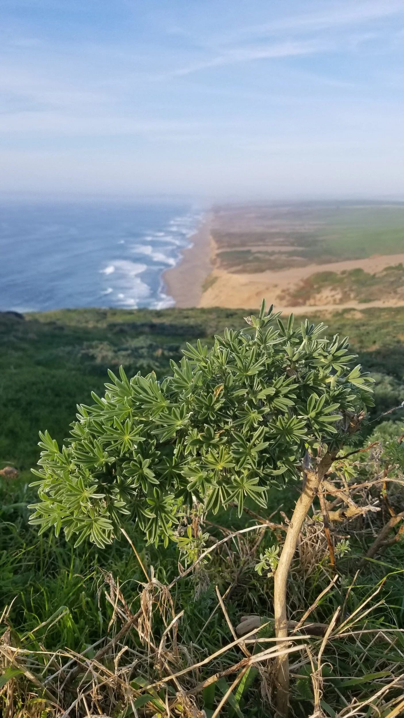
The Coast Looking East From the Lighthouse Area (S8)

Looking East From the Lighthouse Area (S8)
Yosemite is a place that's always been on my list-of-places-to-see/shoot and was next on my list during this trip. This road trip was anchored by a stop in Yosemite and photographing Horsetail Fall's transformation into Firefall. This event requires a specific geometry between the Falls and the sun's path and happens twice per year only one of those times the area is frozen so there is no water flow.
Well, this time of year was far from frozen, it was dry. There was no snow in the park and shooting Firefall only produced a glowing rockface; something I saw in other's images as I refused to devote any time to the event as I knew, no matter what I ended up with, I'd not be satisfied.
My first shoot was the sunset from Valley View.

Yosemite Valley View (S8)
Don and I decided to hike back into Mirror Lake in the hopes of getting some nice reflections. Walking the park left me wishing conditions were better as the water was very low. As we approached Mirror Lake, conditions were no better. The lake was SO low.
I found a perch upon a large boulder in order to get the reflections up out of the grasses along the very shallow shoreline. Setting up I noticed I was missing a tripod foot, again! Damn! Where in Yosemite did I lose one this time!?

Mirror Lake, Yosemite NP (S8)
My focus quickly left shooting and I began pondering the many places the foot could have fallen. I had been so lucky funding all three of my tripod feet when they fell off at Thor's Well along the Oregon coast. Surely my luck was about to run out.
I packed up and began retracing my steps. Tho the trail is only 1.2 miles, we took the scenic route which put the trail closer to 3 miles; three miles each way. 😞
So many thoughts were rolling through my mind as I walked along the trail scanning from left to right. "Would someone pick it up? If so. What would they do with it; throw it? Kick it?"
I took one of the remaining feet off and showed it to people who passed asking, "Excuse me, have you seen one of these?" Every time was the same, a glance straight to the ground, as if searching, and a no. On I walked.
Soon I reached the road that we had walked along. I'd already walked ~1.5 miles and had not seen the foot. Within 500 yards of walking on the road, I saw it!

The Elusive Tripod Foot (S8)
The foot was laying directly in the path of where the bus traffic flowed. Now, I don't mean to say that it was merely in the same lane, I mean to say it was laying where you could clearly see was a worn path where tires continually sped by. The bus drivers had to have been purposely avoiding it, like it was some bolt in the road; which it was. "How could I be so lucky?" I asked myself. I followed that question up with, "How can I fix this situation!?" My plan, but three split washers and install them between the tripod and the tripod feet. That should do it!
Happy to have found my tripod foot, again, we turned our attention to sunset and decided to go up and shoot from Tunnel View. The view from this point is spectacular! Tho, with that being said, and par for the course for my trip to Yosemite, the conditions weren't setting up as I'd envisioned. The skies were merely ok. Regardless, I was in Yosemite! Awesome place!

Tunnel View, Yosemite NP (S8)
The next few days were predicted to have 100% cloud cover in Yosemite. We decided to catch some zzz's and head out in the morning and take advantage of the negative turn in the weather bu using that time to drive. Destination: Death Valley

Death Valley Entrance (S8)
We quickly, over what seemed like 1,000 miles, grabbed a spot to camp and went out exploring the surrounding areas. Badwater was where I wanted to shoot sunrise, so we headed there, the evening prior, in order to scope it out.
The Sunrise was great! About the only way it could have been better was a bit of color in the sky. The walk out to where we wanted to shoot was, to say the least, a bit further than it appeared. This area’s elevation is 282' below sea level.

A Badwater Sunrise (S8)
While the walk is further than it seems, this is a very easy place to get to and I recommend it to anyone who visits Death Valley! The vast number of possible compositions is nearly infinite. I particularly liked the composition below as I liked the “arms” of the salt formations coming into the image from the corners.

A Badwater Sunrise (Prints Available)
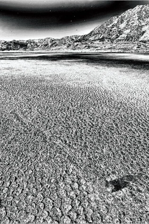
Once the sun came up, the true color of the Badwater Basin's salty floor showed it's true self!

Badwater's Salty Floor (S8)
After shooting Badwater's sunrise, we headed down the road to the Racetrack. This and the Badwater were the two places I wanted to be sure to hit while here.
The road to the Racetrack was a long, slow, and bumpy path. The terrain continuously changed along the way to include a volcano crater, many colorful hillsides, an amazingly decorated roadside sign, and even small Joshua Trees! After about 3hrs, we arrived at the Track!

Teakettle Junction, Death Valley NP (S8)
The Racetrack didn't disappoint other than the tire tracks in the mud and the obvious tampering of some of the rocks. For the most part, everything was legit and untampered with. If you go, my advice, walk far from the initial parking lot. Reserve an hour of walking each way. Good luck!
*Final images of this area will be added once I make it home and run them through post.

Rock Sliding on the Racetrack
Dust was a huge concern while shooting down at the racetrack, tho I was unaware of it while shooting as can be seen below.
With The Racetrack’s surface being somewhat quite solid, I seemingly overlooked the fact that there was still dust in the air, probably coming in from the surrounding desert. With the blowing dust seemingly not on my mind, I ended up with images that had quite a bit of dust spots on them. This was more than likely comprised of both dust on my lens as well as dust on my sensor from any lens changes that I might have done. Oh well, just one more editing step to do.


The last evening in Death Valley found us shooting something a bit different. Instead of a vast landscape, we were going to shoot, more or less, a single point of interest. I’m excited to see this after post-processing as the colors in person were so much better than the back LCD of the DSLR.

Colors From the Artist's Palette (S8)
The last morning in Death Valley found us back at Badwater only this time we were not focusing on the areas of the white salt formations and instead focusing more on the darker and muddier salt formations. I’m excited to see the final images from this shoot. Here is another BTS…

Badwater, Death Valley NP (S8)
Next stop: Sedona!
Sedona never seems to disappoint. What was a bit disappointing was losing my partner in crime to other priorities. He had an issue surface back home in CO and needed to get back. He’d have to catch a flight out, asap.
I made a quick dash down to Phoenix International Airport, dropped him off curbside, and he was on a plane in a matter of no time. Now, where should I go from here?
I decided that, even tho Saguaro National Park was just a bit further down the road to the south, I’d turn back and head into Sedona. I’ve wanted to shoot the area for some time now. It's like a magnet to me.
The following morning found me in the middle of nowhere, driving down a four-wheel-drive road, and searching for a cave up in the rocks in the dark.
The trail to the cave was rather easy to follow and a lot shorter than I’d planned for. Before I knew it, I looked up in confusion wondering where exactly I was and right in front of me was the cave I was looking for! I’d made it, early!

BTS at the Roost (S8)
Where are the high altitude clouds when you need them, huh? You know what they say tho, “When given clear skies, shoot clear sky photos!” I finished the shoot and powered back to the Explorer with another destination in mind.
*Final image of this area will be added once I make it home and run it through post.
My next destination was a nice reminder of how the desert wants me out of it. 🤣
I was following a narrow wash uphill. It seemed like each time I stepped out of the wash there was some form of desert plant life directing me back in. Between the thorns, spikes, and needles, I managed to get what was left of me to my destination; the struggle was just beginning.
The climb up into the cave was quite precarious. I was shooting alone, so I'd have to figure out something that would work solo, both up and down. After studying my options, I decided I’d need to lift up my gear as high as I could and then climb up without it.
I nestled the gear into a shelved crack and climbed up behind it. In an inchworm fashion, both me and my gear made it up into the mouth of the cave. Coming down would be tough!

Looking Through the Keyhole to Sedona (S8)
Shooting from inside the rock wall offers, to me, a nicely framed view of the valley floor below. There are common shots of Sedona everywhere. As a matter of fact, I'll be shooting a very common one tomorrow, assuming there is water available in the foreground landscape. I also wanted to make sure I shot Sedona from a setting that most don't. I’ve got a good buddy to thank for helping me find these locations today. Thanks, Fella! You know who you are!
Earlier in the morning, before heading off to this location, I was running obstacles, that I’d thought were likely, through my mind. The one that kept reoccurring in my mind was the climb down from this location. I decided I’d pack some 550 cord should I need to lower my gear vs climb down with it on my back. Glad I packed that cord!
I tied one end of the cord to the pack handle and put a loop in the cord approximately every three feet. These would serve as handholds so the cord would not run through my hands, burning them in the process, and slamming my gear to the ground below.
It worked like a charm! I lowered my gear down one level and then managed to get the gear to slide down the second level as well, all without leaving the ledge above. Now, it was my turn.

F-Stop Lotus Prepared to be Lowered (S8)
Climbing down was cake! The shoot seemed to go well and it was off down the desert wash and onto my next destinations. Tomorrow is going to be a busy day! I’m planning five stops!
*Final image of this area will be added once I make it home and run it through post.
Cloudy skies were predicted for the coming days. Now, don't get me wrong, I love clouds! They can take an average composition and make it an outstanding composition. Sadly, I've not had good luck with them on this trip, namely in Yosemite.
The types of clouds predicted over the coming days were both high clouds and medium clouds and the cloud cover was in the 90% - 100% range. The high cloud prediction sounded lovely. Often, the sun will reflect off of them coloring them beautiful shades ranging from oranges, pinks, and purples. It was the medium clouds that had me concerned. To me, this spelled snuffed out suns on the horizon, beginning with this particular evening's sunset.

Framed in the Rocks
The skies were looking like they could go either way. This was either going to be an amazing sunset or one heckuva dud. Check back later to see the image from the DSLR and how the sunset turned out!
*Final image of this area will be added once I make it home and run it through post.
With the evening's sunset shot in the bag, I turned my attention to another night in the five-billion star hotel, a quick weather check, and the planning of tomorrow.
Sunset looked to be a 50/50 gamble. If this trip has highlighted anything, it’s that I’m a gambler and that 50/50 odds end up being closer to 25/75 in the end and not in my favor. Regardless, the odds are 0% if I don't get up and go, so that's what I did; I got up and went.
The trailhead parking to the location that I wanted to shoot didn't open until 0800. Sunrise was going to be at 0658. I’d have to find another way to get to my desired shooting location.
Conveniently, or not, I found parking a few trail miles away that didn't have parking hours. I’d have to park there, get there extra early, and trail-hop to my desired location. On par so far.
The trailhead I found was down a road that I’d say bordered on being a 4x4 only road. Again, on par so far.
In the dark, I parked and paid the $5 fee for the convenience of traveling down one of the worse roads in Sedona and id ting in near seclusion. So far so good. Now, where is the trailhead?
Thank goodness for Google Maps! It not only helped me locate the trailhead in the dark but also had zero problems navigating me from one trail to another on my way to the morning's shooting location. Things were looking swell.
The trail was quite long. I hopped from one trail to another and to another. Along the way, I had a sinking feeling deep within. That parking lot way back behind me where I left my car, it sure was dark and isolated. Someone could so easily break into my five-billion star hotel and take their time picking me apart. This brought up a realization, ALL of the images I’ve taken on this trip are in the Explorer! Not only that, but the back-up of the back-up of the images is also in the exact location that the primary storage is in! Fail… Hopefully, when I return, everything will be as I left it and I can address this huge flaw. I’ve got to separate my primary and secondary storage locations!
Pressing on, I couldn't get the image of returning to my vehicle and seeing busted out windows and missing items out of my head. I found myself hiking along having imaginary conversations with fictitious policemen writing assumed theft and vandalization reports. Should I turn back? I decided to press on, tho this didn't erase the worse case thoughts swirling in my head.
Finally, I reached my destination. Sunrise was only moments away. I had made it just in time to scope out a few compositions. I was beginning to get concerned that the clouds on the horizon were going to snuff out yet another sunrise.

Predawn Reflections
After settling on a composition, I set up and waited for the sun. Seemed it was going to be a long wait. 😞 It was looking like I’d witness another tease of a sunrise.
I took a few shots and began pondering the post-production. Would these be good enough? Should I try this spot again tomorrow, regardless of weather predictions, in hopes of something better? I decided to press on, back to “the hotel.” I still couldn't get the thought of all my hard work being gone.
I packed up and began the trek back. I’d thought I saw a few compositions on the way in while hiking in the dark. Right now, I couldn't even remember what they were. On I hiked, eyes peeled, hoping I’d recognize them when I saw them….and then IT happened. I’m sure you can guess what IT is.
The sun busted through the clouds and lit the rock walls overhead, the same rock walls that I had in my reflection composition back down the trail…! Hurriedly, I scampered back to that spot, and by scampered I mean I ran down the trail like a maniac. My camera was at the end of my extended tripod, my water was hooked onto my backpack strap and was flailing all over the place, and one of my hiking boots was 100% untied. Truly professional.
Holy cow, how far down the trail had I hiked!? After what seemed like an eternity, I finally made it back to the pools. I slung my gear down as softly as I could, in the rush I was in, and attempted a composition. Unknowingly, I only had time for one. Unfortunately, it wasn't the one I wanted but had I tried for the better, I'd surely have ended up with nothing as within the time it would have taken me to set-up, the sunshine was gone. The light was not only gone from the tops of the rock walls, but it looked as if it was gone for the morning.

Momentarily Sunlit Rocks
With my heart still racing from the hurried backtracking, and frustration levels overflowing, I packed up and retraced my steps to the parking lot. No longer was I searching out the compositions I thought I saw on the way in. Conditions were now in full flat mode. Clouds now consumed the skies. My attention now turned to the condition of my vehicle and the status of my saved images taken during this whirlwind trip.
A Moment To Reflect
Above is the final image I got from the Seven Sacred Pools area.

Cloud Covered Rocks
Finally, I approached the parking lot. From a distance, I could see my Explorer looked intact. A huge feeling of relief rushed over me! Whew! The first thing I was going to do, when I got to my ride, was to dump these images onto the laptop, back them up to an external hard drive, and immediately physically separate the two.
Having accomplished the file dump and backups, my attention turned to this evening's sunset. It was looking like a bust in the Sedona area. I decided to move on. Only Q, should I go North or South? 🤔 I decided…., South.
I decided my next destination would be the ole White Sands National Monument now the newly named White Sands National Park! It would add a few miles to the trip, but I’m obviously not scared of a few miles.

The White Sands of White Sands NP
Pulling up to White Sands, I wasn't initially all that impressed. The place seemed rather small and, from what I could see, there was a lot of plant life where I'd hoped there'd be nothing but sand. Regardless, I pressed ahead and went into the visitor's center. After all, I had to get my stickers for my vehicle topper and my passport stamped. 😉
I talked to the Ranger behind the information desk. I was curious about how to best maximize my time since I only had a sunset and a sunrise available to me in the park.
She mentioned to me that the far West end of the Dunes was higher and wider. I asked about shooting night photography. She said the park closed at 1900 and that I'd better be driving to the gate by 1845 if I was to make it out in time.
Pulling past the information center, and towards the entrance to the park, I noticed that there was a sign that read "Backcountry Permits Available." If I got one of those, then I'd be able to shoot some night shots! "Wonder why the lady at the information desk didn't mention anything about this option when I asked about night shooting?” I thought to myself. 🤔
I pulled up to the pay booth and inquired about the permit. "Sure," the Ranger said. "Just fill out this permit. It'll be $3." Heck yeah! Now, I'd be able to shoot after closing and/or before the park opens!
I filled out the permit, paid the lady, and told her that I was going to swing back by the Visitor's Center in order to fill all of my water bottles since there is no water available in the park. "No problem!" she said as she handed me my permit.
I thought about going and chatting with the lady at the information desk concerning why she didn't mention the backcountry permits as an option. Upon arriving at the Visitor's Center, I decided to just fill my water and go. With my water filled, I returned to the entrance, passed on through, and then headed out towards backcountry camping parking.
The parking lot was clear on the other side of the park, which was fine by me. I'd rather not have to deal with a bunch of people anyways.
Upon arriving at the parking lot, I stopped to read the information board. It seemed I'd not be camping next to my vehicle and that I'd need to pack all of my camping gear and trek it back into the Dunes to "spot #3." This camping location was on my permit, so was a map, but somehow that didn’t clue me in that I'd be carrying my gear through the sand dunes back to a particular location. It was crystal clear now tho.
How was I going to haul all of the necessary camping gear back to my still unseen spot as well as all of my camera gear? After loading one backpack, that I just happened to bring along on the trip, with water, a tent, sleeping pad, sleeping bag, stove, food, a couple of jackets, and a few other essentials, I threw it over my back. "Well," I thought to myself. "I guess I'll be making two trips."
The park is set up so that you follow a series of tall fluorescent signs. Eventually, when you feel like you've walked half of the Earth, you'll come upon spot #1 or spot #10 if you are walking the trail backward. I came upon spot #1 and looked a bit further up and could see what I thought to be a sign for spot #2. Remember earlier when I said that I thought the park was small? Well, I take it back!
Sure enough, spots #2 and #3 were a bit further up the "trail" and not too far from each other, tho spaced far enough that you'd feel as if you were alone in the desert. Awesome!

Campsite #3, White Sands National Park
The winds were blowing just enough that putting up a tent, while solo, would be a challenge. With that, I laid the tent out, and by laid it out I meant that I held it out as if flew around flapping in the wind. I identified the door, spun accordingly so that the door was facing where I wanted and staked the upwind corner of the tent down with the rest of the tent still flapping wildly. After staking the other three corners, the tent poles and the tent itself went up easy peasy. Now, to hike back up the trail and go get my camera gear.
On the walk back to my car, I decided that I was not making two trips in the morning. Heck no! I was going to wear my camera bag normally and my camping equipment bag on the front of me! I was going to double bag it! Forget all of these extra miles. Geesh, If I only had a dollar for every mile I hiked while on this trip!
I made it back to the car with little problems. By little problems, I mean blisters. I was walking barefoot in the sand. Felt great, tho I guess my big toes didn't care too much for it. Bummer. Oh well, I grabbed my gear and hobbled back to camp.
I must have been pretty anxious to go shoot. Once I made it to camp, I simply walked by and went composition hunting. This was going to be difficult.

The Powdery Sands of white Sands National Park
It wasn't difficult due to there not being any compositions, hardly. It was going to be difficult due to the vast amount of them. I came to the park with one of them in mind. I must have passed a zillion decent spots before settling on this evening's sunset situation. I could see it up ahead on the horizon, just a few bazillion miles further... 😳
I bet from a casual observer's perspective it looked pretty neat watching me pop up here only to disappear and pop up elsewhere as I trekked my way towards the horizon. Slowly, but surely, my composition location was indeed getting closer.
Somewhere between observing the composition and actually getting there all of the winds on Earth decided to blow on this single patch of sand in New Mexico. I could barely see and couldn't open my bag in order to get much of anything out as I didn't want sand all in it. There'd be no changing lenses for me. I decided to pop a wide lens on and press with it for the evening. With that being said, rest assured I saw about 100 compositions that required a long lens.
I finally made it to my previously scoped out sunset composition. Now, I typically treat sand like I treat snow. I'll stalk my composition before approaching it in order to help alleviate putting footprints where I want to shoot. There's nothing worse than unwanted footprints in a shot besides your own unwanted footprints in a shot.

BTS, White Sands Sunset
The winds had to have been hitting 45-50 MPH and carrying tons of sand. I set my tripod up and hung by a fairly heavy camera bag from its center. This worked to both keep the tripod from blowing over and allowed me to get the bag up off the dune floor further allowing me to access it, somewhat. Awesome! Now, only two more hours until sunset. 😞

F-Stop Lotus Tripod Weight
I couldn't sit down. When I did, the sand blew directly into my face. If I turned my back to the blowing sand, it created an eddy of sorts and, again, blew sand into my face. I'd have to stand and wait for sunset. Yay.
After timing how long it takes footprints to disappear, two minutes by the way, peeing in the hurricane-force winds, not into the wind by the way, and anything else that I could come up with to kill some time, it was finally time for sunset!

Did I Eat Sand For This?
While not the miraculous sunset that I'd envisioned, it came, it went, and I took my shots. The setting sun would be sinking fast and night wouldn't be far behind. I needed to book it back to camp.
There were many reasons for this. One, I didn't want to be trying to find camp in the dark and in the howling wind. Two, I was getting hungry and my snacks weren't cutting it. Three, I left my two jackets in the first backpack that I brought from the parking lot to camp. Yeah, you know the same camp that I barely stopped at on my way out to shoot. Well, I was supposed to grab a jacket. Luckily I had a set of thermals stored in my camera bag. Doesn't everyone? 🤔
I put the thermal top on and threw my old t-shirt over the top of it. I'd dropped breadcrumbs in Google Maps every now and then when I was on the way out, so getting to camp as the crow flew would be no problem. The problem would be navigating the Dunes at dark. I wanted none of that, so I high-tailed it towards camp.
It seemed like every 50 yards I wanted to stop and shoot a scene. Over and over I'd walk and either talk myself out of shooting or stop, set-up, shoot, pack-up, and get moving again. Keep in mind, the winds have died down none. None!
I made it back to camp rather uneventfully. Once back, I grew about 55 more arms and managed to get my rain fly on my tent, alone, and in the wind. I wanted it on! I wanted anything that'd get me out of this wind!
The forecast for the morning was for cloudy skies. I set a 0400 alarm in the hopes that the forecast was once again wrong like so many other times on this trip. Sadly, the forecast proved accurate on this particular morning.
My 0400 alarm woke me up right on time. Those things are a lot easier to hear without earplugs in as you sleep. This was something that I'd previously been doing but had no need for way out here in the Dunes.
I took a peek out at the skies and sure enough, barely a star visible. Bummer. I was really looking forward to taking a Milky Way pano with the sands glowing blue under a starlit sky. Well, on to plan-B, a 0530 alarm and high hopes for hot pink and orange sunrise clouds!
I mentioned "high hopes" in an effort to project optimism. In reality, I was not that optimistic. Peeking out of the tent after my sunrise alarm woke me further buried my optimism. It was way too cloudy for anything other than flat images of dimly lit dunes at sunrise.

The Morning After
It was unfortunate that this grand trip sort of went out on a whimper. I was really looking forward to seeing what I know is possible at White Sands. Sadly, it'll have to be on another trip; a trip I'm guaranteed to take in the not too distant future!
Total Miles = 5,891
Vehicle Run Time: 151hr:10min:39s